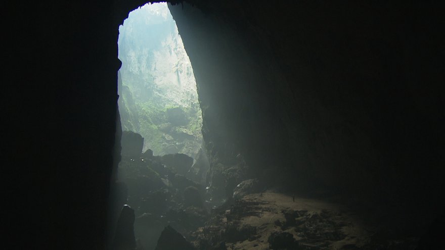
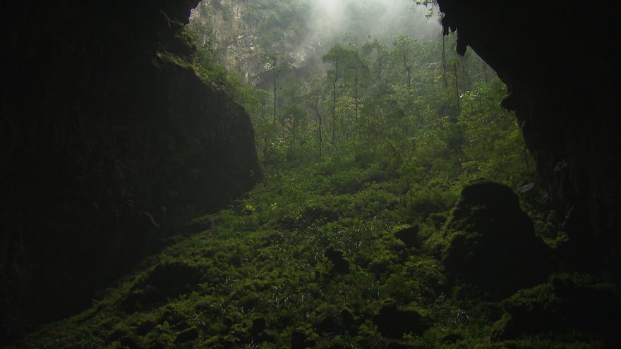
Son Doong cave (in Vietnamese: Hang Sơn Đoòng, meaning Mountain River Cave) is a cave in Phong Nha-Ke Bang National Park, Bo Trach District, Quang Binh Province,Vietnam. The cave is located near the Laos-Vietnam border. It has a large fast-flowing underground river inside.
The cave was found by a local man named Hồ-Khanh in 1991. The local jungle men were afraid of the cave for the whistling sound it makes from the underground river. However, not until 2009 was it made known to the public when a group of British scientists from the British Cave Research Association, led by Howard and Deb Limbert, conducted a survey in Phong Nha-Ke Bang from April 10-14, 2009. Their progress was stopped by a large calcite wall.According to Limbert, this cave is five times larger than the Phong Nha cave, previously considered the biggest cave in Vietnam. The biggest chamber of Son Doong is over five kilometers in length, 200 meters high and 150 meters wide. With these dimensions, Son Doong overtakes Deer Cave in Malaysia to take the title of the world's largest cave. Enjoy some of the beautiful pictures illustrating the natural beauty of Son Doong.
Read the expedition Story

A half-mile block of 40-story buildings could fit inside this lit stretch of Hang Son Doong, which may be the world’s biggest subterranean passage. (Photo Credit:
© Carsten Peter/National Geographic)
 Like a castle on a knoll, a rock formation shines beneath a skylight in Hang Son Doong. A storm had just filled the pool, signaling that exploring season was coming to an end.(Photo Credit: © Carsten Peter/National Geographic)
Navigating an algae-skinned maze, expedition organizers Deb and Howard Limbert lead the way across a sculpted cavescape in Hang Son Doong. Ribs form as calcite-rich water overflows pools. (Photo Credit: © Carsten Peter/National Geographic)

Son Trach, Bo Trach District, Vietnam. (Photo Credit: © NGC)

Son Trach, Bo Trach District, Vietnam. (Photo Credit: © NGC)

Son Trach, Bo Trach District, Vietnam. (Photo Credit: © NGC)

Son Trach, Bo Trach District, Vietnam. (Photo Credit: © NGC)

Hang Song Doong aka Mountain River Cave, Son Trach, Bo Trach District, Vietnam. (Photo Credit: © ITV STUDIOS LTD./ Simon Reay)

Hang Song Doong aka Mountain River Cave, Son Trach, Bo Trach District, Vietnam. (Photo Credit: © ITV STUDIOS LTD./ Simon Reay)

Hang Song Doong aka Mountain River Cave, Son Trach, Bo Trach District, Vietnam. (Photo Credit: © ITV STUDIOS LTD./ Simon Reay)

Hang Song Doong aka Mountain River Cave, Son Trach, Bo Trach District, Vietnam. (Photo Credit: © ITV STUDIOS LTD./ Simon Reay)

Hang Song Doong aka Mountain River Cave, Son Trach, Bo Trach District, Vietnam. (Photo Credit: © ITV STUDIOS LTD./ Simon Reay)

Hang Song Doong aka Mountain River Cave, Son Trach, Bo Trach District, Vietnam. (Photo Credit: © ITV STUDIOS LTD./ Simon Reay)

Hang Song Doong aka Mountain River Cave, Son Trach, Bo Trach District, Vietnam. (Photo Credit: © ITV STUDIOS LTD./ Simon Reay)


Back to top
"Past the hand of dog, watch out for dinosaurs,” says a voice in the dark.
I recognize Jonathan Sims’s clipped, British military accent but have no idea what he’s talking about. My headlamp finds him, gray muttonchops curling out from beneath his battered helmet, sitting alone in the blackness along the wall of the cave.
“Carry on mate,” growls Sims. “Just resting a buggered ankle.”
The two of us have roped across the thundering, subterranean Rao Thuong River and climbed up through 20-foot blades of limestone to a bank of sand. I continue alone, following the beam of my headlamp along year-old footprints.
In the spring of 2009, Sims was a member of the first expedition to enter Hang Son Doong, or “mountain river cave,” in a remote part of central Vietnam. Hidden in rugged Phong Nha-Ke Bang National Park near the border with Laos, the cave is part of a network of 150 or so caves, many still not surveyed, in the Annamite Mountains. During the first expedition, the team explored two and a half miles of Hang Son Doong before a 200-foot wall of muddy calcite stopped them. They named it the Great Wall of Vietnam. Above it they could make out an open space and traces of light, but they had no idea what lay on the other side. A year later, they have returned—seven hard-core British cavers, a few scientists, and a crew of porters—to climb the wall, if they can, measure the passage, and push on, if possible, all the way to the end of the cave.
The trail disappears before me into a difficult pile of breakdown—building-size blocks of stone that have fallen from the ceiling and crashed onto the cave floor. I crane my head back, but the immensity of the cave douses my headlamp’s tiny light, as if I were staring up into a starless night sky. I’ve been told I’m inside a space large enough to park a 747, but I have no way to know; the darkness is like a sleeping bag pulled over my head.
I switch off my headlamp just to feel the depth of the darkness. At first there is nothing. But then, as my pupils adjust, I’m surprised to make out a faint, ghostly light ahead. I pick my way through the rubble, almost running from excitement, rocks scattering beneath my feet and echoing in the invisible chamber. Traversing up a steep slope, I turn a ridge as if on a mountainside and am stopped in my tracks.
An enormous shaft of sunlight plunges into the cave like a waterfall. The hole in the ceiling through which the light cascades is unbelievably large, at least 300 feet across. The light, penetrating deep into the cave, reveals for the first time the mind-blowing proportions of Hang Son Doong. The passage is perhaps 300 feet wide, the ceiling nearly 800 feet tall: room enough for an entire New York City block of 40-story buildings. There are actually wispy clouds up near the ceiling.
The light beaming from above reveals a tower of calcite on the cave floor that is more than 200 feet tall, smothered by ferns, palms, and other jungle plants. Stalactites hang around the edges of the massive skylight like petrified icicles. Vines dangle hundreds of feet from the surface; swifts are diving and cutting in the brilliant column of sunshine. The tableau could have been created by an artist imagining how the world looked millions of years ago.
Jonathan Sims catches up with me. Between us and the sunlit passage ahead stands a stalagmite that in profile resembles the paw of a dog.
“The Hand of God would be just too corny,” he says, pointing at the formation. “But the Hand of Dog does nicely, don’t you think?”
He clicks off his headlamp and unweights his gimpy ankle.
Back to top
“When we first got to the collapsed doline, that skylight up there, I was with another caver and we both had four-year-old sons, so we were experts on dinosaurs, and the whole scene reminded us of something right out of Sir Arthur Conan Doyle’s novel
The Lost World,” he says. “When my partner went exploring forward into the sunlight, I told him to ‘watch out for dinosaurs,’ and the name stuck.”
Two decades ago, the leaders of this expedition, Howard Limbert and his wife, Deb, became the first cavers to visit Vietnam since the 1970s. Back then, the country’s caves were legendary but unexplored. In 1941 Ho Chi Minh had planned his revolution against the Japanese and French in Pac Bo Cave north of Hanoi, and during the Vietnam War thousands of Vietnamese hid from American bombing raids inside caves. The Limberts, experienced cavers from the Yorkshire dales of northern England, made contact with the University of Science in Hanoi and, after obtaining sheaves of permits, mounted an expedition in 1990. They’ve made 13 trips since, not only discovering one of the longest river caves in the world—12-mile Hang Khe Ry, not far from Son Doong—but also helping the Vietnamese create 330-square-mile Phong Nha-Ke Bang National Park, which now attracts a quarter million Vietnamese and foreign visitors a year. Tourists, who dramatically increase the income of local villagers, come to see the park’s namesake show cave, Hang Phong Nha, which workers light up like a psychedelic rock concert.
Because of the dense jungle, the Limberts might never have found the caves without help from area residents. “Mr. Khanh has been with us from the beginning,” Howard says, nodding toward a thin man smoking a cigarette beside the campfire. We’re squatting around the fire just inside the entrance to Hang En, the mile-long portal that tunnels beneath a ring of mountains into the lost world. “Couldn’t have done it without him,” Howard says. Ho Khanh’s family lived in a nearby village. His father was killed in the war, forcing Khanh at a young age to fend for himself in the jungle. For years he hunted all over this border country, taking refuge in caves when it rained, or rained bombs.
“It took three expeditions to find Hang Son Doong,” Howard says. “Khanh had found the entrance as a boy but had forgotten where it was. He only found it again last year.”
Stands of bamboo and other vegetation cover mounds of limestone here, making the place all but impenetrable. Below the surface, this part of Vietnam is one immense limestone block, says Darryl Granger, a geomorphologist from Purdue University. “The whole region was squeezed upward when the Indian subcontinent smashed into the Eurasian continent 40 to 50 million years ago,” he says. Hang Son Doong was formed two to five million years ago, when river water flowing across the limestone burrowed down along a fault, scouring out a giant tunnel beneath the mountains. In places where the limestone was weak, the ceiling collapsed into sinkholes, creating the gigantic skylights.
Anette Becher, a German caver and biologist, has found wood lice, fish, and millipedes inside the cave that are all white, which is common for creatures that live in the dark. And Dai Inh Vu, a botanist from the Vietnam Academy of Science and Technology, has identified the plants growing beneath the skylights, finding basically the same mix that grows in the forest above. But such science on the run is not the real focus of this expedition, whose central purpose is exploration. For cavers like the Limberts, discovering a cave as big as Hang Son Doong is like finding a previously unknown Mount Everest underground. “We’ve just scratched the surface here,” Howard says of the national park, which was named a World Heritage site in 2003 for its forests and caves. “There is so much more to do.”
Back to top
When Howard and Deb first saw these enormous spaces, they felt certain they had discovered the largest cave in the world—and they might be right. There are longer caves than Hang Son Doong—the Mammoth Cave system in Kentucky, with 367 total miles, holds that record. There are deeper caves too—Krubera-Voronja, the “crow’s cave,” plunges 7,188 feet in the western Caucasus Mountains of Georgia. But for giant passages, there are few caves that can compare. At the time of the Limberts’ discovery of Hang Son Doong, the largest passage was thought to be Deer Cave in Malaysian Borneo’s Gunung Mulu National Park, which was recently surveyed at 1.2 miles long, 500 feet wide, and 400 feet tall. But as the explorers would eventually determine, using precise laser instruments, Hang Son Doong is more than 2.5 miles long with a continuous passage as wide as 300 feet and, in places, over 600 feet high.
“We weren’t actually searching for the largest cave in the world,” Deb says. But she’s thrilled that the cave’s newfound fame might improve the lives of local villagers.
After five days of hiking, hauling, and crawling, the expedition is still only halfway into the cave. Counting all the cavers, scientists, a film and photography crew, and porters, we are a team of more than two dozen, which seems to have slowed us down. Besides that, the going gets dangerous as we climb through the breakdown in Watch Out for Dinosaurs: One misstep on slick boulders could mean a fall of more than a hundred feet.
When we reach the next skylight, the Garden of Edam (another cheesy pun), it’s even bigger than the first, almost as wide as the roof of the Superdome in New Orleans. Below the opening is another mountain of breakdown with a jungle of hundred-foot-tall trees, lianas, and burning nettles. As our time and supplies begin to run out, Howard decides the moment has come to send an advance team ahead to the Great Wall of Vietnam, to see if an assault is really possible.
Back to top
The wall lies more than a mile away at the end of a corridor shaped like a V with a foot-deep trench of water at the bottom. Mud walls, sticky as peanut butter, rise 40 feet high on either side. It is not possible to walk in the trench, only to stumble. By the time you reach the wall, you’re so covered in mud you appear to have gone swimming in chocolate pudding. The cavers named this passage Passchendaele, after the trench warfare battle of World War I in which the Allies lost 310,000 soldiers to gain only five miles of ground near the Belgian village of Ypres.
Climbing an overhanging 200-foot-tall wall of mud is technical, risky business, so you need just the right type of madmen. Luckily, Howard has handpicked Gareth “Sweeny” Sewell and Howard Clarke for the advance team. The two have been caving together for 20 years in the nastiest potholes in England. Clarky is a bull semen salesman, and Sweeny is a legal specialist who somehow convinced his wife that they should sell their one and only car so he could keep heading off on caving expeditions.
The first day at the base of the wall, as Clarky belays, Sweeny begins boldly working his way upward, drilling hole after hole. Almost all of the holes are too hollow to hold a screw from which to hang their ropes.
For 12 hours they jabber in their expletive-laden Yorkshire vernacular—“ez bloody crap covered wit mood,” Sweeny says at one point. Neither says a word about the true dangers of the task. Were any of the six-inch screws to pop out, the rope Sweeny is hanging on would lose its anchor and he’d likely zipper the rest of the screws and plummet to his death.
On the second day of the climb, after bivouacking at the bottom of the wall for the night, Sweeny returns to his previous high point, with Clarky belaying again. Soon enough the whirring of his drill echoes through the domed blackness, Sweeny so high up we can see only the glimmer of his headlamp. At two in the afternoon—of course it doesn’t matter a bit what time it is when it’s dark 24/7—after 20 hours of drilling holes and climbing higher, Sweeny finally disappears over the wall and some minutes later we hear:
“AAIIOOOOO!!”
Clarky ascends the rope next, then yells down for me, the words bouncing through the cave: “Well, ye comin’ up or wat!”
At the top of the Great Wall of Vietnam we can literally see light at the end of the tunnel and start howling our heads off. The rest of the expedition will later tell us that they actually heard our hallos more than a mile away in the cave. Measurements made at the top of the wall will reveal that from the bottom of Passchendaele to the ceiling is 654 feet. It’s just the three of us now, exploring. No human has ever been here before. We drop down off the backside of the Great Wall and begin ascending a staircase of rock toward the exit.
“Will ye look at deese!” roars Clarky, kneeling beside a dried-up pool. Sweeny and I gather around. Inside the pool, illuminated by our headlamps, are cave pearls.
Cave pearls are formed when a drop of water from the ceiling hits the limestone floor and throws up a speck of rock. This grain is jostled in its little cup of stone every time a drop hits it. Over thousands of years, a solid, almost perfectly round calcite pearl is formed.
Pearls are rare and in most caves are no larger than a marble. The cave pearls here are the size of baseballs, larger than any the cavers have ever seen. (Their preternatural size may be due to the enormous distance the ceiling waterdrops fall.)
“I ’ereby christen this passage Pearl ’arbor,” Clarky announces.
Back to top
Twenty more minutes and we’re scrambling up and out of the cave. It is raining in the jungle. We hack our way far enough out into the forest to recognize a horizon and determine that this is not just another skylight, but that we have discovered the end of Hang Son Doong. Sweeny and Clarky are far too humble to openly express that we’ve just completed the first push through what is very likely the largest cave passage in the world.
 CLICK HERE FOR MORE INTERESTING STORIES




 Tweet
Tweet